Weather report for Thursday August 24
- Aug 24, 2023
- 2 min read

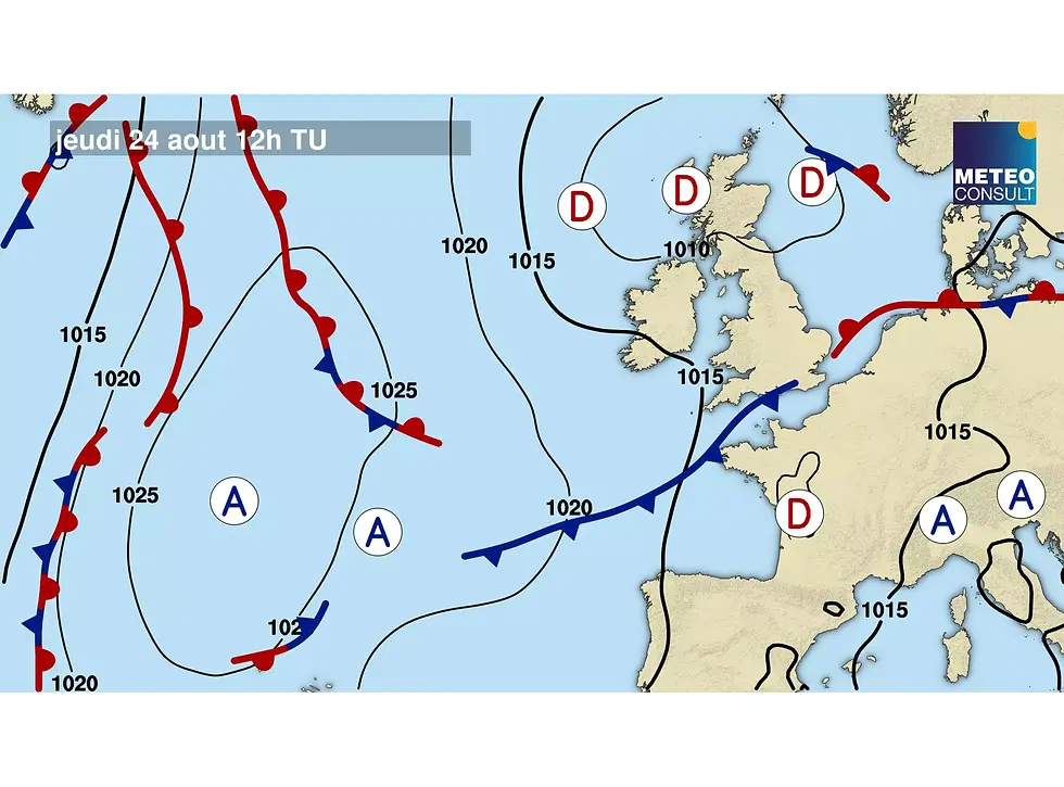
General Situation:
This Thursday, unstable weather situation under the influence of stormy depressions rising from the Bay of Biscay towards the English Channel and the North Sea.
Friday, moderate westerly flow under the influence of a vast low pressure system stretching from the British Isles towards Denmark and Poland.
Saturday, unstable west to southwest flow under the influence of a low pressure system extending from the British Isles to Scandinavia.
Weather conditions in Caen
Thursday, August 24
Passage of heavy rain storms in the early morning then the weather remains unstable with sunny spells and cloudy periods that can be accompanied by showers.
Wind: variable 10 to 20 km/h, strong gusts possible during thunderstorms (60-80 km/h).
Temperature: 18° to 26°C
Risk of precipitation: 100%
Friday, August 25
Good weather with sunshine and a few cloudy periods
Wind: west 15 to 25 km/h
Temperature: 15° to 21°C
Risk of precipitation: 10%
Saturday, August 26
Alternating sunny spells and cloudy periods that may be accompanied by showers.
Wind: southwest to west 15 to 25 km/h, gusts 40 km/h
Temperature: 14° to 22°C
Risk of precipitation: 60%
Sunday, August 27
Alternation of sun and cloudy periods that can be accompanied by showers.
Wind: west to northwest 15 to 30 km/h
Temperature: 14° to 21°C
Risk of precipitation: 50%
Weather conditions for the start of the first stage in Ouistreham at 1:02 p.m.
The reliability of the forecast is estimated at 90% to see good wind conditions for the start of this first leg of the Solitaire du Figaro Paprec 2023. The skippers will set off under a west-northwesterly wind moderate in the order of 12 knots. The sun will alternate with cloudy periods that can be accompanied by showers with gusts of 15 to 18 knots. The sea will be light with a west-northwest swell of around 70 cm. Ideal weather conditions for a race start...
Weather conditions at sea for the first stage from Ouistreham to Kinsale
Sunday, August 27
In the afternoon, for the first miles off the Normandy coast towards the first passage mark "west Saint Marcouf", the westerly wind will gradually strengthen to reach 15 to 18 knots at the end of the daytime. With a wind coming from the bow of the sailboats, the sailors will have to make a few tacks to reach the Cotentin in a sea that will become a little rougher with a northwesterly swell of 1.2 m. During the first night of navigation, they will have a first Channel crossing to make between the Cotentin and the Isle of Wight off the southern coast of England. They will cross a weakly disturbed front with a rotation of the wind from west-southwest to west-northwest. Gusts of 25 knots may occur as the front passes. The sailors will have to be vigilant and make some sail adjustments. At the end of the night, the northwesterly wind will weaken off the English coast.
“For more information, visit the website https://figaronautisme .meteoconsult.fr/


